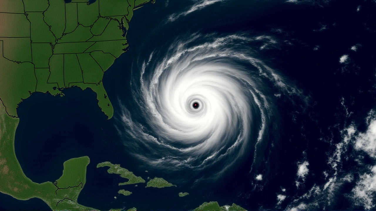
When NOAA dropped its official forecast for the 2026 Atlantic hurricane season this week, the headline was surprisingly calm: below-average activity. For coastal communities still nursing memories of recent battering seasons, that’s a breath of fresh air. But here’s the thing—quiet doesn’t mean safe. The agency predicts fewer storms overall, but the ones that do form could still pack a serious punch.
The outlook, released by the National Weather Service and the National Hurricane Center, covers the standard window from June 1 through November 30. It calls for 8 to 14 named storms, 3 to 6 hurricanes, and 1 to 3 major hurricanes. To put that in perspective, an average season typically sees about 14 named storms and seven hurricanes. So yes, we’re looking at a lighter load—but not an empty one.
The El Niño Factor
So why the lull? The primary culprit is El Niñothe Pacific Ocean. This climate pattern, characterized by warmer-than-average sea surface temperatures in the central and eastern Pacific, creates atmospheric conditions that are hostile to Atlantic storm development. Specifically, it increases wind shear—the vertical change in wind speed or direction—which essentially tears apart forming tropical systems before they can strengthen.
Forecasters note there is a 55% chance the season will be below-normal, a 35% chance it will be near-normal, and only a 10% chance it will be above-normal. That 55% probability is driven largely by the expected strength of El Niño during the peak of the season. It’s a classic meteorological trade-off: when the Pacific heats up, the Atlantic often cools down in terms of storm activity.
A Tale of Two Basins
While the Atlantic might see a reprieve, the Eastern Pacific is bracing for something quite different. NOAA projects a 70% likelihood of above-average activity in that basin. They’re forecasting 15 to 22 named storms, with 9 to 14 reaching hurricane strength and 5 to 9 becoming major hurricanes. This inverse relationship is typical during El Niño years; energy shifts from the Atlantic to the Pacific, fueling more intense and frequent storms off the coast of Mexico and Central America.
It’s worth noting that independent forecasters, like those at Colorado State University, have issued slightly higher estimates for the Atlantic, predicting 13 named storms, 6 hurricanes, and 2 major hurricanes. While their numbers are closer to the long-term average than NOAA’s lower bound, both agencies agree on the overarching trend: El Niño is suppressing Atlantic potential.

Don't Let Your Guard Down
Here’s the twist: a "below-normal" forecast can be dangerous if it leads to complacency. Warmer ocean temperatures globally provide ample fuel for any storm that does manage to bypass the wind shear. As one broadcaster pointed out, "it’s not a zero risk." A single Category 4 hurricane hitting a populated coastline can cause billions in damage, regardless of how quiet the rest of the season was.
Major hurricanes—defined as Category 3, 4, or 5 storms with winds of at least 111 mph—are still part of the equation. NOAA’s range of 1 to 3 major hurricanes means we should expect at least one powerful system. And remember, these storms don’t just stay offshore. Inland flooding from rain bands and tornadoes spawned by outer spirals remain significant threats throughout the Southeast and Midwest.

What Comes Next?
In the immediate term, NOAA says no tropical development is expected across the Atlantic Basin over the next 7 to 10 days. But that short-range view changes quickly. Meteorologists will be watching the evolution of El Niño closely over the coming months. If the pattern weakens earlier than expected, the Atlantic could wake up faster than predicted.
Residents along the Gulf Coast and the Atlantic seaboard should use this quieter forecast as an opportunity to prepare, not relax. Check your insurance, clear gutters, and review emergency plans. The season starts June 1, and while the odds favor a calmer year, nature always has a way of surprising us.
Frequently Asked Questions
Why is the 2026 Atlantic hurricane season expected to be below normal?
The primary driver is the anticipated development of El Niño conditions in the Pacific Ocean. El Niño increases wind shear over the Atlantic, which disrupts the formation and intensification of tropical storms. This atmospheric interference makes it harder for systems to organize into hurricanes, leading to a lower overall count compared to historical averages.
Does a below-normal forecast mean there will be no hurricanes?
Absolutely not. A below-normal forecast simply means fewer storms than the long-term average. NOAA still expects 3 to 6 hurricanes and potentially 1 to 3 major hurricanes. Even in quiet seasons, individual storms can cause catastrophic damage if they make landfall in populated areas. Preparation remains essential.
How does the Eastern Pacific forecast compare to the Atlantic?
The forecasts are nearly opposite. While the Atlantic is expected to be below average due to El Niño, the Eastern Pacific is projected to be above average with a 70% probability. This region may see 15 to 22 named storms, including 5 to 9 major hurricanes. El Niño typically suppresses Atlantic activity while enhancing Pacific activity.
What is the difference between NOAA's and Colorado State University's forecasts?
NOAA provides a probabilistic range (8-14 named storms), emphasizing the likelihood of below-normal activity. Colorado State University offers a specific point estimate (13 named storms, 6 hurricanes). Both align on the influence of El Niño, but CSU's numbers are slightly closer to the climatological average, suggesting a potentially less severe suppression than NOAA's lower bounds imply.
When does the 2026 Atlantic hurricane season officially begin?
The Atlantic hurricane season runs annually from June 1 through November 30. However, tropical activity can occur outside these dates. NOAA’s outlook was released in mid-May 2026, just weeks before the official start date, providing early guidance for emergency managers and residents.